Last updated September 18, 2024
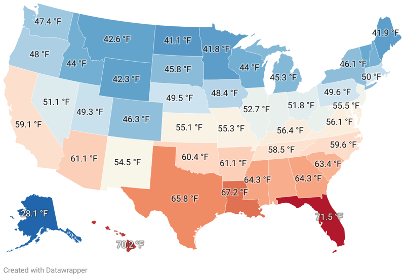
| 1. | Florida | 71.5 °F | |
| 2. | Hawaii | 70.2 °F | |
| 3. | Louisiana | 67.2 °F | |
| 4. | Texas | 65.8 °F | |
| 5. | Georgia | 64.3 °F | |
| 6. | Mississippi | 64.3 °F | |
| 7. | Alabama | 63.7 °F | |
| 8. | South Carolina | 63.4 °F | |
| 9. | Arkansas | 61.1 °F | |
| 10. | Arizona | 61.1 °F | |
| 11. | Oklahoma | 60.4 °F | |
| 12. | North Carolina | 59.6 °F | |
| 13. | California | 59.1 °F | |
| 14. | Tennessee | 58.5 °F | |
| 15. | Kentucky | 56.4 °F | |
| 16. | Delaware | 56.3 °F | |
| 17. | Virginia | 56.1 °F | |
| 18. | Maryland | 55.5 °F | |
| 19. | Missouri | 55.3 °F | |
| 20. | Kansas | 55.1 °F | |
| 21. | New Mexico | 54.5 °F | |
| 22. | New Jersey | 53.6 °F | |
| 23. | Illinois | 52.7 °F | |
| 24. | West Virginia | 52.7 °F | |
| 25. | Indiana | 52.5 °F | |
| 26. | Ohio | 51.8 °F | |
| 27. | Nevada | 51.1 °F | |
| 28. | Rhode Island | 50.8 °F | |
| 29. | Connecticut | 50 °F | |
| 30. | Pennsylvania | 49.6 °F | |
| 31. | Nebraska | 49.5 °F | |
| 32. | Utah | 49.3 °F | |
| 33. | Massachusetts | 48.9 °F | |
| 34. | Iowa | 48.4 °F | |
| 35. | Oregon | 48 °F | |
| 36. | Washington | 47.4 °F | |
| 37. | Colorado | 46.3 °F | |
| 38. | New York | 46.1 °F | |
| 39. | South Dakota | 45.8 °F | |
| 40. | Michigan | 45.3 °F | |
| 41. | New Hampshire | 44.2 °F | |
| 42. | Idaho | 44 °F | |
| 43. | Wisconsin | 44 °F | |
| 44. | Vermont | 43.2 °F | |
| 45. | Montana | 42.6 °F | |
| 46. | Wyoming | 42.3 °F | |
| 47. | Maine | 41.9 °F | |
| 48. | Minnesota | 41.8 °F | |
| 49. | North Dakota | 41.1 °F | |
| 50. | Alaska | 28.1 °F |
The United States, with its broad geographical span and varied topography, presents a rich tapestry of climate zones. From the sub-arctic chill of Alaska to scorching desert temperatures in the Southwest, the nation's weather patterns are as diverse as its landscapes. The interplay of geographical location, altitude, coastal influences, and latitude creates unique climatic footprints across the states, impacting everything from lifestyle choices to economic pursuits. This article investigates these distinct climate differences across the U.S. The provided dataset details the average annual temperature for each state, listed from the highest to the lowest. Notably, two conspicuous factors seem to influence the distribution: latitude and proximity to the coast. Thus, we see the warmest states clustered in the South and Southeast regions, while northern inland states generally exhibit cooler temperatures. Key findings from the dataset are: